TEMPO steps up the pace of air pollution monitoring
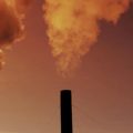
Forget about worrying if rain will spoil your picnic. Soon you can worry about whether it’s acid rain—or if the formaldehyde levels are too high to go for a run.
Imagine having an app on your phone that in addition to the weather, gives you up-to-date information on the ever-changing soup of chemical pollutants floating in the air around you. Harmful chemicals and their concentrations would be listed on your phone screen, tailored to a 10-kilometer area surrounding your phone’s location beacon.
That day is coming soon thanks to a new instrument known as TEMPO built by Ball Aerospace & Technologies to the requirements of scientists at the Smithsonian Astrophysical Observatory in Cambridge, Mass. It is scheduled to launch into space in summer 2022.
Looking down from an orbit some 22,000 miles above the Earth, TEMPO will monitor key pollutants in the air above North America, such as nitrogen dioxide (NO2), ozone (O3), formaldehyde (HCHO), sulfur dioxide (SO2), halogen oxides (BrO, OClO), wood smoke, microparticles and other aerosols known to have a negative impact on human health. TEMPO will provide up-to-date details of greater North America’s air quality during daylight hours, scanning the region hourly from east to west.
TEMPO’s principal investigator, Kelly Chance, Associate Director for Atomic and Molecular Physics and Senior Physicist from the Center for Astrophysics | Harvard and Smithsonian, answers a few questions about this exciting new project that he has been shepherding to fruition for more than a decade.
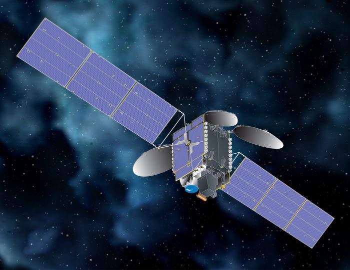
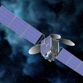
Image of a generic communications satellite with the TEMPO instrument (blue and silver at bottom) (Image courtesy Maxar Technologies)
What does the acronym TEMPO stand for?
Tropospheric Emissions Monitoring of Pollution. From space TEMPO will see visible and ultra-violet wavelengths absorbed by specific chemicals floating in the lower atmosphere—the troposphere—over North America. Sunlight striking the Earth’s surface and then scattering back through the air to TEMPO’s detectors will reveal the identity, concentration and movement of these airborne chemicals every hour while the sun is shining.
From this data TEMPO will create a constantly changing map of the chemicals in the air that will be overlaid onto geographic maps of the continental United States. In doing this, TEMPO will revolutionize air-quality forecasts and emission control strategies and enable public warning of pollution events before or as they happen.
Will TEMPO’s maps be more accurate than what is in use now?
TEMPO will have a 10-square kilometer resolution, much smaller than those of the current spectrometers in low earth orbit. TEMPO is expected to improve air quality prediction accuracy across North America by at least 50 percent and greatly improve daylight measurements of the broad range of atmospheric pollutants listed above.
TEMPO’s timely and accurate measurements of poor air-quality events will allow asthma sufferers, the elderly, young children and others at risk to take proper precautions. Every hour TEMPO’s data will be analyzed by a team of scientists at the Smithsonian Astrophysical Observatory and archived and distributed by at NASA’s Atmospheric Science Data Center in NASA Langley Research Center, Hampton, VA. In addition, TEMPO has science teams in Canada and Mexico and additional teams are currently being assembled in Hispaniola and other islands in the Caribbean.
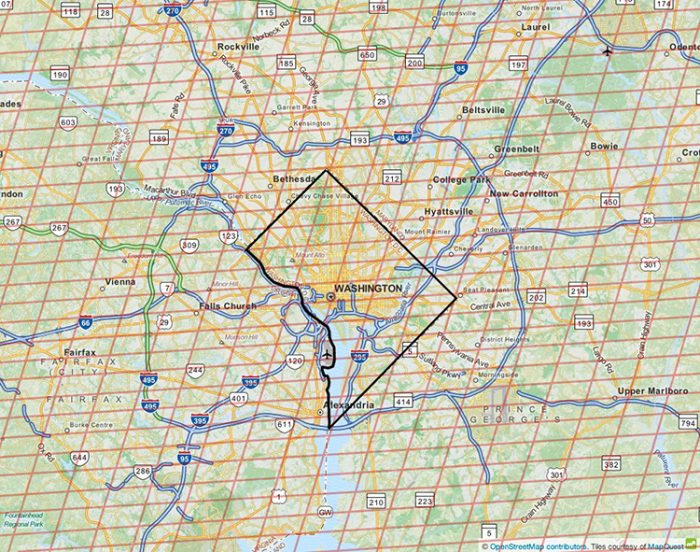
The TEMPO mission will measure air pollution at a resolution of 10 square kilometers as indicated by the orange squares in this map of the Washington, D.C. region.
When will TEMPO be launched and how soon will it be operational?
It is currently scheduled to be launched in late July-early August 2022. Intelsat and Maxar Technologies have agreed to host the TEMPO instrument onboard one of their Intelsat 40e satellites, which is a commercial satellite that provides communications for Intelsat customers in North and Central America.
TEMPO will be in a geostationary orbit 22,000 miles above the equator at a location 0 degrees North-South and 91 degrees West, which is just a little to the west of New Orleans. Because TEMPO’s orbit will match the Earth’s orbit of 24 hours, from the ground the satellite will appear to be stationary—just sitting there in space.
Once TEMPO is in orbit, we will need about 6 months to put the instrument through its paces, test our algorithms, and validate our initial measurements and results. It’s going to take a lot of work.
Already, Ball Aerospace & Technologies has conducted rigorous testing and calibration to verify this sensitive device works properly and will survive all of the challenges it will encounter during its launch, and sustained operation in space.
By 2024, TEMPO will be one of three satellites monitoring air pollution around the world. South Korea’s Geostationary Environment Monitoring Spectrometer rocketed into space this spring and is monitoring the atmosphere over Asia. The European Space Agency is expected to launch a satellite in 2023 that will take measurements over Europe and North Africa.
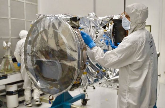
The TEMPO instrument is a grating spectrometer, sensitive to visible and ultraviolet wavelengths of light, that will measure sunlight reflected and scattered from the Earth’s surface and atmosphere back to the instrument’s detectors and collect data on key elements of air pollution. IT will provide near-real-time North American air quality information that will be available to the public. Here it is shown in a clean room maintained by Ball Aerospace and Technologies Corp. (Photo courtesy Ball Aerospace)
How much of North America will be seen by TEMPO?
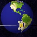
All of the lower 48 states plus a bit of Alaska, most of Canada, most of Mexico and almost all of the Caribbean, including Hispaniola and Puerto Rico. The area an instrument like TEMPO monitors is called its ‘field of regard.’
TEMPO will be required to spend much of each hour scanning its full field of regard, for as many daylight hours as can be arranged. Some observing time however, as much as 25 percent during certain periods, will be available for focusing on the chemicals being released by specific events such as volcanic eruptions, forest fires, dust outbreaks and significant storms. For example, lightening is known to produce large amounts of nitrogen oxide, which partly oxidizes to become the pollutant nitrogen dioxide. By pinpointing where and when intense thunderstorms are predicted and using TEMPO to begin measuring at high resolution in these areas before, during and after a thunderstorm, we can deepen our understanding of lightening-produced nitrogen oxides and their environmental impact.
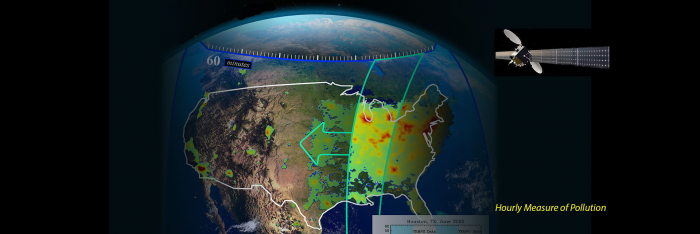
TEMPO’s field of regard, or the area where it will take measurements, is outlined in green. TEMPO will measure air pollution in North America from Mexico City to the Canadian oil sands and from the Atlantic Ocean to the Pacific Ocean. Credit: NASA/USGS/SAO.
What other things will TEMPO help us understand?
Well, for example, if TEMPO were in orbit today, we could be part of a consortium looking into the effects of the Covid-19 pandemic…a big deal at the moment. We could take a closer daily look at the reduced amount of pollution being generated by cars and other commuter vehicles every weekday morning and evening on the East and West coasts. Transportation is one of the most significant sources of pollution we create. Because vehicles are constantly on the move, and traffic varies widely throughout the day, the pollution it creates is incredibly difficult to track.
TEMPO will also have agricultural applications and could potentially change how fertilizer is used. Farmers spend a fortune each year on fertilizers that they think are going to help them have more bountiful crops. We know however that when it rains right after the application of fertilizer much of the fertilizer applied to crops simply evaporates into the atmosphere. This fertilizer pollution is the equivalent of wasted money to the farmers that bought and applied it. TEMPO’s observations will help us better understand this phenomenon and potentially correct it.
TEMPO measurements of O3, NO2, H2CO, C2H2O2, and aerosols in the air above oil and gas fields will contribute to a better understanding and quantifying of the chemical evolution of air pollution caused by oil and gas drilling and fracking.
While not specifically intended for night-time observations, TEMPO provides an interesting capability for studying nightlights as markers for surface pollution, human activity, and energy conservation. By collecting night-time light spectra TEMPO can help map the many different types of outdoor lighting used across the U.S., including mercury vapor, high and low-pressure nitrogen lamps, and LEDs.
TEMPO will be able to take quantitative readings of pollution output from certain regions, Cuba for example, that could help inform the state of developing or receding economies. Pollution and economic prosperity are generally highly correlated.
Where is the TEMPO instrument today and what stage is its completion?
TEMPO’s development and manufacture was finished in 2019 by Ball Aerospace & Technologies in Boulder, Co., and while NASA has taken ownership of the TEMPO flight hardware, the instrument will remain in storage at Ball until it is integrated to the satellite and tested, to prepare for launch.
TEMPO is the first instrument to be funded with an award under NASA’s Earth System Science Pathfinder Program in the Earth Venture Instrument Class Series.

Dr. Kelly Chance
The TEMPO Science Team is a collaboration of scientists from multiple U.S. and international organizations with extensive experience in measuring the components of air quality from space. Members of the Science Team include: Principal investigator: Kelly Chance, Smithsonian Astrophysical Observatory; Instrument development: Ball Aerospace & Technologies Corporation; Project management: NASA Langley Research Center; other collaborators NASA Goddard Space Flight Center, National Oceanic and Atmospheric Administration, Environmental Protection Agency, National Center for Atmospheric Research, Harvard University, University of California at Berkeley, St. Louis University, University of Alabama Huntsville, University of Nebraska, University of Puerto Rico, Sitting Bull College, The National Autonomous University of Mexico RT Solutions and Carr Astronautics. International collaboration: Korea, Europe, Canada, Mexico. For more information on TEMPO go to TEMPO.si.edu
Related posts:

Posted: 29 July 2020
-
Categories:
Astrophysical Observatory , Collaboration , Feature Stories , Science and Nature


